|

|
|
| Product Information: | ||
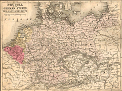
| Details: | 1886 Map of Prussia; 1 pp; Map; Published: 1886; 10.5x14; Item # FS060 This is a full color reproduction of an 1886 map of Prussia from Mitchell’s New School Atlas, Mitchell’s Modern Atlas: A series of Forty-Five Copperplate maps by E.H. Butler & Co. Areas include Prussia and the German States, Holland and Belgium. Note: What appear to be roads are railroads. All of these maps come in a protective, archival safe sleeve. |
|